Data formats
DSO Planner text format
Each object is represented by a text string which starts with " & " symbol and then contains pairs of the form "field=value" separated by " ; " symbol. The pairs could be put into a text string in any order. It is possible to use only some fields and omit other, in this case omitted fields will be automatically set to 0 or zero string. To deal with several objects at once place several lines into the text file, every line corresponding to its own object.
If you need to use " & " or " ; " within the value (e.g. within text fields), just put " \\ " in front of the symbol: " \\& " or " \\; ".
Standard data fields
- ra — Right ascension in epoch 2000. Its value lies in 0 to 24 range.
- dec — Declination in epoch 2000. Its value lies in -90 to 90 range.
- a — Object dimensions in arc minutes, longer axis.
- b — Object dimensions in arc minutes, shorter axis.
- pa — Position angle in degrees.
- name1 — Short object name.
- name2 — Long object name.
- comment — Text comment on an object (truncated to 50 characters).
- mag — Magnitude of an object.
- type — Object type.
- typestr — The name of the custom user type. This field is required only if you use your own (custom) object type (e.g. using custom object type you could assign a "meteor" type to your objects).
Additional (custom) object fields
If standard object fields are not sufficient for object description one could use any number of additional fields. Additional fields could have the following types:
- Text — Text field.
- Double — Fractional number field.
- Integer — Integer number field.
- Image path — Field with a path to an image on SD card.
- Web link — Field with a web link.
Auxiliary fields
When exporting or importing data, DSO Planner uses several auxiliary fields for database reference, note description, location description, etc. Users should not use these names for their object description:
- afov
- aperture
- catalog
- date
- id
- latitude
- longitude
- note
- notebaseid
- path
- selected
- time
Possible abbreviations
- ngc — Simplifies import of NGCIC objects. Just use object description in the form &ngc = <object number>, for example: &ngc=3031;
- ic — Simplifies import of NGCIC objects. Just use object description in the form &ic = <object number>; for example: &ic=2;
Examples
Double star from WDS (Washington double star) catalog:
&name1=00000+7530;name2=00000+7530;ra=0.001844;dec=75.483276;mag=10.27000;pa=235;type=ds;year=1982;
          components=;mag2=11.50000;spectrum=;separation=0.600001;
This double star description uses the following custom fields (see Creating User Database).
- year — Integer number.
- components — Text string.
- mag2 — Double number.
- spectrum — Text string.
- separation — Double number.
Dark nebula from Lynds catalog:
&name1=LDN1;name2=LDN1;ra=16.480963;dec=-16.107859;opacity=3;a=13.942740;b=13.942740;type=neb;
Bright nebula from Lynds catalog:
&name1=LBN1;name2=LBN1;ra=17.752939;dec=-28.851336;brightness=5;a=4;b=4;type=neb;
Temporary and Permanent Objects
Affects data Import operations and manual adding of custom objects (See important to understand details here).
Object Types reference
The following object types are used throughout the program:
- GC — Globular cluster
- Gx — Galaxy
- GxyCld — Galaxy cloud
- HIIRg — HII region
- Neb — Nebula
- OC — Open cluster
- OCN — Open cluster nebula
- PN — Planetary nebula
- SNR — Supernova remnant
- mPlanet — Minor planet
- Planet — Planet
- Star — Star
- DS — Double star
- Comet — Comet
- CG — Cluster of galaxies
- DN — Dark Nebula
- AST — Asterism
- QS — Quasar
- NF — Not found
- CUSTOM — User defined type. Any string could be set as a user (custom) object type (typestr)
User Horizon file format
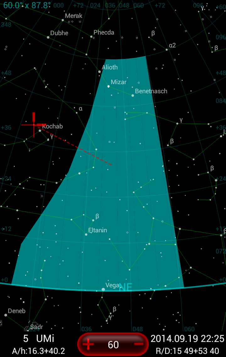
Figure 19: User horizon on the Star Chart

You can show your local horizon on the Star Chart, if you can prepare a text file with coordinates of the key points, describing your local horizon line, in the simple format, where each row in the file represents the coordinates pair of Azimuth and Altitude in degrees for each point. The last point will be automatically linked with the first one in the file. For example (Figure 19 above) shows a fake user horizon, defined by the following data file:
19 0
20 10
30 30
40 60
60 60
61 0
The easiest way to prepare such a file would be on a good night observe stars which are visible near the edges of significant local horizon's obstructions (window or balcony frame, buildings walls, hills or trees contours, etc) and use their coordinates and coordinates of other, less visible, stars from the map to approximate the key points for the horizon's line. Another approach - make a panoramic image in known projection, find the key points, measure their x,y coordinates on the image, and finally convert them to the Azimuth and Altitude values for the file.
Telescopes list export file
The export file format is fairly simple. Each telescope has a single line record in it, like:
&name=zhumell;focus=1550.0;eyepieces=1;pass=80.0;descr=;aperture=305.0;
where randomly placed name=value; entries are defining the following information:
- name - the arbitrary short ID name for the telescope record;
- focus - (mm) focal length of the telescope lens, objective, mirror, or of the entire optical system in millimeters;
- aperture - (mm) the size of the telescope lens, objective, mirror, or of the entire optical system in millimeters;
- descr - arbitrary long line of text, - description of the instrument;
- pass - (%) the pass-through coefficient of the telescope optics, required as all the real optics is quite far from it's theoretical model. 80% is typical for a good Newtonian reflector.
- eyepieces - is set to 1 if the telescope has some eyepieces assigned to it already.
Eyepieces list export file
The export file format is fairly simple. Each eyepiece has a single line record in it, like:
&name=Ethos 17;scopes=1,2;focus=17.0;descr=Primary piece;afov=100.0;
where randomly placed name=value; entries are defining the following information:
- name - the arbitrary short ID name for the eyepiece record;
- focus - (mm) focal length of the eyepiece;
- afov - (deg) the Apparent Field Of View of the eyepiece in degrees;
- descr - arbitrary long line of text, - description of the eyepiece;
- scopes - the comma separated list of telescope indexes, to which this eyepiece is assigned to. Indexes corresponds to the record number in the telescopes' list.
Visibility value explained
Object visibility is measured on 0-5 scale,where 0 is invisible and 5 bright. Visibility depends on object brightness and dimensions, sky condition (its limiting magnitude - the magnitude of the faintest star one could see at zenith), telescope aperture, its passthrough and magnification (that is an eyepiece used with the telescope). Blackwell model is used for visibility calculations.
Visibility is not calculated for comets and objects with absent magnitude or dimension. For such objects visibility is considered a missing parameter. Set Empty field treatment as you need to include / exclude such objects when filtering them in the Object Selection module.
As an exception if dimension is missing in planetary nebula, minor planet, or double star its visibility is calculated as that of a star (point-like lighting source).
Detection limit is a minimum visibility threshold: when using visibility filter to look for objects only objects with visibility above or equal to the detection limit are found.